Advanced Grid Interfaces for Environmental e-Science: Urban Pollution
Summary |
Progress To Date |
Publications |
People |
Miscellaneous
The Advanced Grid Interfaces for Environmental e-Science project (Main Page) looks
at how sensors and user can be integrated into the eScience
programme. Currently eScience focuses on data or computation heavy
applications and in some respects neglects the fact that science is
often done with large numbers of data sources and large numbers of
users.
Two demonstration scenarios are considered:
- Studying carbon cycling in Antarctic lakes, a demonstrator
that as well as deploying new sensors, looks at integration of data and access to that data with geographically dispersed collaborators. (See page at Nottingham.
- Environmental science in urban environments, a demonstrator
looking at data integration between multiple static and mobile sensors
with the aim of building and visualising a detailed map of pollution
in London.
UCL works on the 2nd of these.
Environmental science in urban environments
Modern cities face daunting problems of population density, transport
management and regeneration in both economic and social terms. At UCL,
the Centre for Advanced Spatial Analysis, the departments of Geomatic
Engineering and Geography, and the Bartlett School of Architecture and
Planning have been collaborating in the general area of urban
environmental science, developing frameworks for analysis and
simulation. This includes macro-scale data from sources such as the
National Environmental Technology Centre and also kerbside data from
sensors such as Streetbox that have been developed at UCL and deployed
within London.
Existing tools to understand the city, such as graphical modelling of
the built environment, simulation and mapping of transport flows and
pollution levels, tend to lead to isolated and relatively static
models. We propose to provide an integrated visualization system that
will allow presentation of models at the urban scale on a range of
devices from mobile PDA through to Reactor. Our primary demonstration
will be of a user physically present in the urban environment
collaborating with a remote ReaCtor user over a visualization of data
concerning their common geographical area.
Within the City Project UCL is most interested in the rendering,
modelling and interaction issues. We are continuing work on modelling
and visualization of pollution data in urban context.
The following pages detail our work to date (latest work first)
Papers
- A. Steed, S. Spinello, B. Croxford, C. Greenhalgh, e-Science in the Streets: Urban Pollution Monitoring, UK e-Science All Hands Meeting, September 2003, [ PDF (0.5M) ]
Talks
- S. Spinello, Automatic City Model Generation from Ordnance Survey Data, (Caltech, May 2003) [ PDF (1.5M) ]
UCL CS
-
Research Fellow: Richard Milton
-
Research Fellow: Dr Salvatore Spinello (now in Bordeaux)
-
UCL PI: Dr Anthony Steed
Project Sites
- Nottingham
- Glasgow
- RCA
- Sussex
UCL Collaborators
This EPSRC Grant GR/R81985/01
Links of interest
Anthony STEED
Last modified: Thu Oct 14 13:51:51 BST 2004
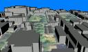 3D Visualisations of all the data from DAPPLE, Camden, UCL and Clerkenwell